
Ever wondered why Karakura has such big mountain ranges? Why the weather is so diverse? What else there is on Karakura Island?
It’s all explained by the Geography of this small offshore Japanese Island.
Written by Hashi Ino
It’s all explained by the Geography of this small offshore Japanese Island.
Written by Hashi Ino
Karakura, the island.
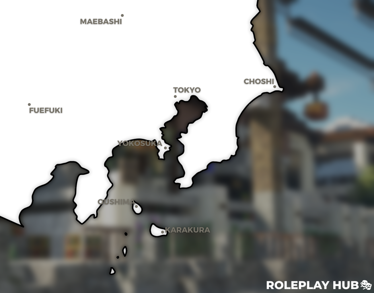
Along its 102.25km square length, Karakura is divided up by the Kohaku Mountain Range, with Karakura City being nestled right in the mountain range, seeing as Karakura’s oblong form and dividing mountain range characterize it as a suburban and rural island.
Due to its oblong form, Karakura divides itself into 4 major parts of the island by the Kohaku Mountain Range, those being: Karakura City, Kampo Forest, Itsbyoshi Forest, and Ochiba Forest. Around 1998, the Karakura Government divided Karakura City up into its own unique 12 districts: Karakura Plaza, Karakura High School & College, Business Park, North-western Karakura, Teams’ District, Karakura Shopping District, Motokawa-Karakura, Kaigan-Karakura, Shizukanamichi-Karakura, Karakura Pier, Itsbyoshi-Karakura, and Ochiba-Karakura. Most of these districts are straight forward with what is located within them, but others might be a little tricky to figure out, so here is a list of landmarks / remarkable places within each district.
(1) Karakura Plaza:
- The Karakura Plaza / Flag Garden.
- Karakura High School & College
- Apartment complexes J,K,M,N,O,P,Q,R,S,T, and U.
- The Karakura Hospital
- The News Station
- The Abandoned Power Plant
- The Townhall
- All of the sports teams' houses, along Karakura Avenue.
- The Bowling Alley
- Former Autoshop & other miscellaneous shops.
- The Shopping Center & its apartment complexes.
- The Graveyard
- A row of low-maintenance residential houses, formerly a river-like, crime filled area. Located in front of the Shopping District.
- The Karakura Police Department
- The Beachside
- The waterpark
- The new Karakura Stadium & Convention Center
- The Former Akihito Officer
- The Skatepark
- Ushinokoya Restaurant
- The Karakura Pier
- The Lighthouse
- The Saiky & Akihito Estates
- Complex K
- The Itsbyoshi Trail
- The Ochiba Forest
- The Shinsei Seinaru Monastery
Through the Diaoyu Tunnel, located in the North-western district, it connects Karakura City up with the western coastline, as well as provide passage to the rural district of Tsubasa, containing a small library, grocery store, clinic and delivery center, but most importantly it is where the Karakura Elementary school is located, as well as the Karakura International Airport. Providing itself as an introduction point to any newcomers.
Karakura’s Nature.
Karakura is an island filled with bright, blooming and flourishing nature. From the neatly kept flowers to the abundance of trees within the Ochiba Forest. But that is only if we look within the scope of Karakura City. If we zoom out to a full-sized image of the entire island of Karakura, the rich history and still existing nature that is nestled on this island becomes clear.
The Island of Karakura is fitted with many different forests along its surface, mainly known to us citizens as the Itsbyoshi and Ochiba forest, both of which have small parts of their territory within the Kahuka Mountain Range, surrounding Karakura City. But outside of the mountain range there are many different forests covering up the surface of the island. Those forests being: Shizukanamichi woods, Kampo Forest, Ogonshoku woods, Motokawa forest, and the Ichikawa forest.
- Through the Tōge Tunnel, on Masayoshi boulevard, Citizens can make their way through the Itsbyoshi forest to the Yagi groves. A flat and fertile plot of land in between the Itsbyoshi Forest and Ichikawa Woods, where most of Karakura’s agriculture is located.
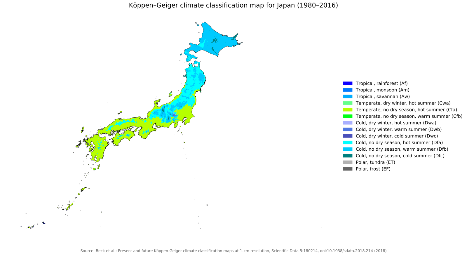
Köppen-Geiger climate classification map for Japan, 1980-2016
Karakura’s weather.
As mentioned previously, Karakura’s climate is very diverse, colder and wetter towards the north and more warm towards the south. However our weather is still in a very changing pattern, even changing so drastically that floods, sinkholes, tsunamis and earthquakes happen every once in a while, even to our humble little island. This is because of Japan’s and Karakura’s geological placement on the Tectonic plates on earth.
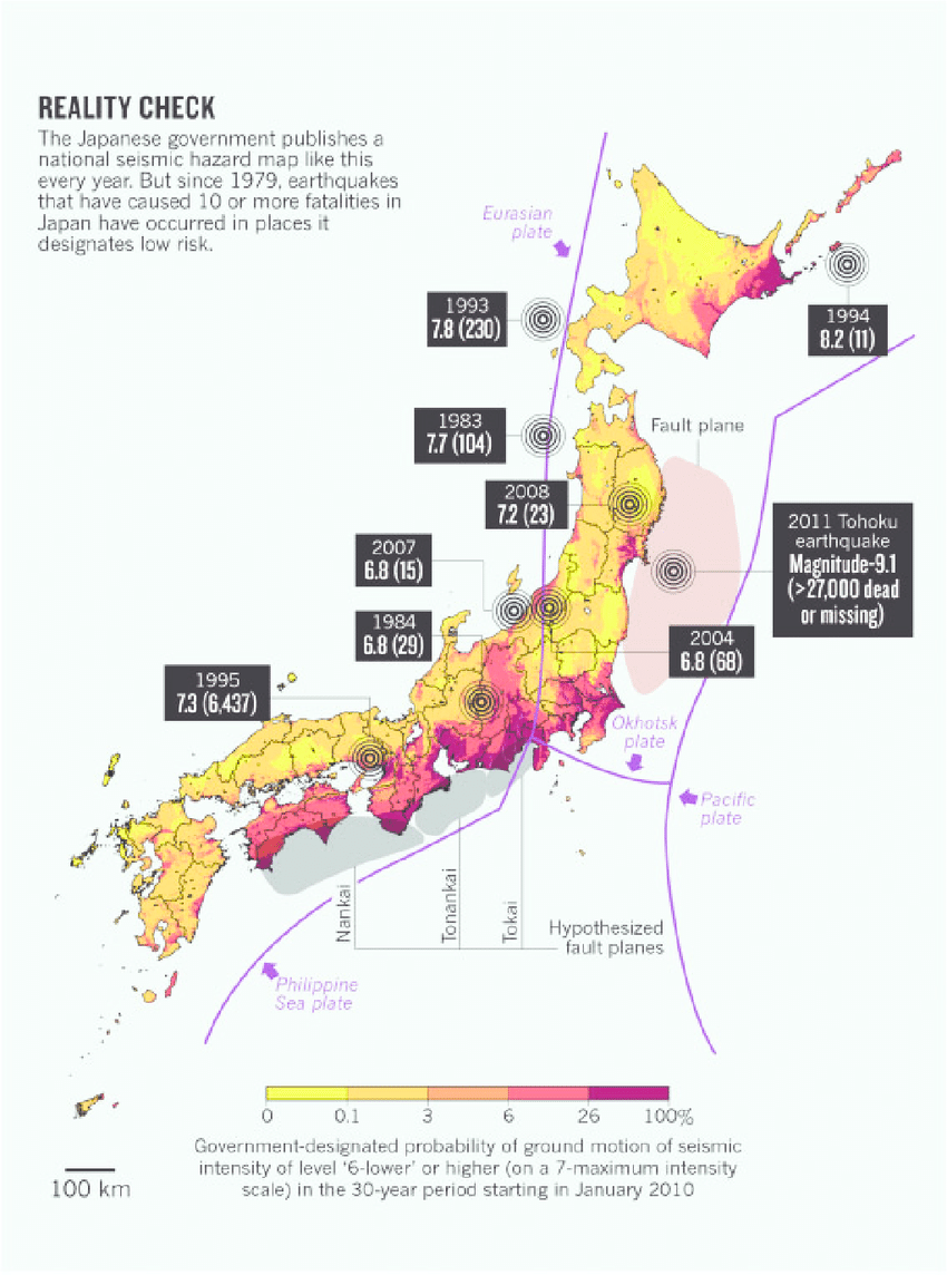
Karakura is located right near the Okhotsk plate, and very close to both the Philippine Sea plate and Eurasian plate, which is connected to the Philippine Sea plate and goes through mainland Japan. Because Japan is directly located on these tectonic plates, or very close to it - same with Karakura island - it is prone to have more and heavier natural disasters, which have happened before on Karakura. Think back to the Earthquake which happened on April 17th, 2023. Or Hurricane Luau, on the 10th of March, 2023. It is no new sight for Karakura to be hit by one of these natural disasters, all because of our geographic placement.
The rapidly changing climate situation, especially in our modern era of today's world, always brings the question; When will be the next disaster? Sadly, we cannot really know beforehand, but due to repeated live-action ‘testing’ it is with a safe heart to say Karakura’s infrastructure and core buildings are ones to handle all kinds of disasters, just like they have done within the past.
For now we must wait and see, and hope this winter brings us not too cold weather, but just warm enough for Karakura’s citizens to endure. And hopefully not too much rain either. This is all for now for the report! Hashi Ino, closing off.
Have something you'd like to report or be reported on? Call the Reporter Hotline at (020) 980-4487 or message us on OnRain @KaNews!


